On foot along the pilgrimage route through Switzerland

I did this part of the way with my wife Vreni and "pilgrim" Vera as a Sunday outing. We started at Märstetten station.
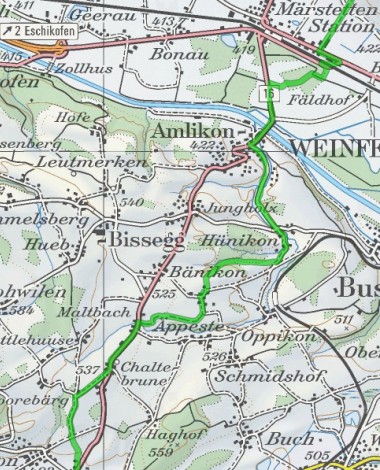
The path leads near Amlikon over the Thur and over Hünikon and Holzhäusern to Maltbach, Kaltenbrunnen, Affeltrangen and Tobel. The signposting under the name "Schwabenweg" (Swabian path) is excellent.
At the end of the hike we made a detour to Lommis, where we visited the church of St. James with the Idda chapel.
The stage beer was served (after car transport) on the terrace of Sonnenberg Castle. (On the map below left: Sunebärg)

This signpost is located shortly after the railway crossing at Märstetten. Still 2325 km.
Besides the simple arrows "Schwabenweg" there are such beautiful signposts at the most important places.
Near Amlikon we crossed the Thur. Here has always been an important crossing. Before the first wooden bridge was built in 1728, there was a ferry here.
On the Schwabenweg, shortly after Hünikon.
The Restaurant Biene in Maltbach, a half-timbered house from the 18th century, was once said to have served as a hostel. But the landlady doubts this.
On the left-hand side of the entrance to the fountain is a baroque chapel of St. James (1779/80) with a gabled roof and ridge turret. It is the successor to a former chapel from 1662. The otherwise austere interior contains a stained glass window in the northern choir window with a portrait of the pilgrim patron saint.
Above Bollsteg there is a splendid view of the Affeltrangen and Tobel area with far-reaching views as far as the Hörnli and the Swiss mountains.
The timber-framed building in Bollsteg from the middle of the 18th century had a pilgrims' hostel as its predecessor. The tavern is attested in 1549.
The church of Affeltrangen with mooing foreground.
A side trip led us to the St. Jacob's Church in Lommis and to the Sonnenberg Castle. From there we enjoyed a wonderful view of the Swiss mountains.