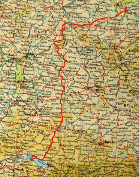
On the road on German pilgrimage routes by bike (1000 km, 621.5 miles)

Click on the shell symbol
![]() to go to the pilgrimage report with many photos*)
to go to the pilgrimage report with many photos*)
or click on one of the stages
Stages |
km |
|---|---|
|
77.4 km |
|
|
85.0 km |
|
|
76.5 km |
|
|
81.4 km |
|
|
49.4 km |
|
|
49.6 km |
|
|
78.3 km |
|
|
82.6 km |
|
|
56.3 km |
|
|
92.0 km |
|
|
97.8 km |
|
|
92.5 km |
|
|
82.0 km |
Travel documents
Pilgrimage guide: Der ökumenische Pilgerweg, the ecumenical pilgrimage route through Saxony, Saxony-Anhalt and Thuringia. This guide covers the route from Görlitz to Vacha and also includes a pilgrim's passport.
Orders to:
Ökumenischer Pilgerweg e.V.
Goetheplatz 9 B
D-99423 Weimar
info@oekumenischer-pilgerweg.de
Cycle Tour Maps 1:150,000 of the German Bicycle Club e.V.
No. 13, 17, 21, 25. My maps were not up to date, new cycle paths were not marked.
Leaflet: Jakobusweg Fulda-Schweinfurt, route description and accommodation directory
and hiking map "Naturpark Rhön" (Fritsch Verlag) 1:50,000 ". For foot pilgrims to Würzburg there would be another map "das Schweinfurter Land".
The Way of St. James is marked. For me as a cyclist, the map was very helpful, e.g. with the question: How do I get safely back down to Langenleiten from Kreuzberg by bike?
Orders to:
Rhönklub e.V.
Peterstor 7
D-36037 Fulda
hauptvorstand@rhoenklub.de
Pilgrim's Guide: Der Jakobusweg von Fulda nach Würzburg (The Way of St James from Fulda to Würzburg) by Rudolf Beck, Michael Imhof Verlag, ISBN 3-9355590-95-4
Leaflet: Der Unterfränkische
Jakobusweg, The Lower Franconian Way of St. James (Schweinfurth - Würzburg) by the Franconian St. James Society,
available at the (highly recommended) pilgrims' accommodation "Löwenzahn", Gartenstr. 37, D-97422 Schweinfurth (T: 09721-201130).
lies on in the (highly recommended) pilgrim accommodation "Löwenzahn", Gartenstr. 37, D-97422 Schweinfurth (T: 09721-201130)
Pilgrim's Guide: Jakobusweg II (Ulm - Oberdischingen - Äpfingen - Biberach - Steinhausen - Bad Waldsee) by Gerhilde Fleischer, ISBN: 3-7966-0905-8
Pilgrim's Guide: Jakobusweg III (Bad Waldsee Weingarten - Ravensburg - Brochenzell - Markdorf - Meersburg - Konstanz) by Gerhilde Fleischer, ISBN: 3-7966-0798-5
City maps of the larger cities from the German tourist office
Information from the internet:
http://www.jakobus-info.de/
*) a special thanks to St. James: I must have been under his special protection, because I found the lost camera again - otherwise there would be no photos here.